Historical Information
Washington County was part of the Louisiana Purchase in 1803. It later became part of Nebraska and Kansas Territories. In 1861, it was part of Weld and Arapahoe Counties.
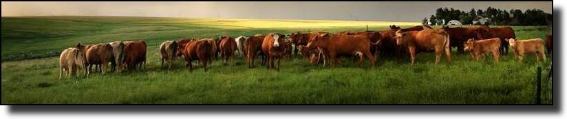
In the early 1880’s, Weld County occupied all of northeastern Colorado which served as a vast open range, primarily for three cattle companies – John Iliff’s, Jared L. Brush’s and Bruce Johnson’s 22 Ranch which covered most of present day Washington and Yuma Counties., Homesteaders objected to the vast distance to the county seat in Greeley and in 1884 submitted a petition to divide Weld County in half with the eastern half to constitute Iliff County. The cattle barons roared in protest of the petition and nothing came of the 1884 effort to break up Weld County into small counties.
An act of the Colorado General Assembly created Washington County, named for the “Father of his Country” (George Washington) on February 9, 1887. In 1889, Yuma County was taken from the eastern half of Washington county. In 1903, the current boundaries were established.
Some early communities included: Abbott, Akron, Anton, Arickaree, Brunker, Burdett, Cope, Curtis, Denova, Dillingham, Elba, Flat Top, Fremont, Gilchrist, Glen, Harrisburg, Henry, Hyde, Leslie, Meekton, Messex, Otis, Pinneo, Plum Bush, Platner, Prairie, Rago, Simpson, Spence, Thurman, Wagner, Waitley, Willadel, Woodrow, Xenia.
Incorporated towns in Washington County are Akron. Unincorporated communities include: Anton, Cope, Last Chance, Lindon, Otis, Platner and Woodrow.
The highest point of elevation in the county is 5433 feet situated at the Washington-Lincoln County line 11.8 miles south of Last Chance on Hwy 71 and 2.2 miles east on County Road 0, The lowest point of elevation in the county is in the far northeastern corner at 3913 feet just north of county road 54 east of Lone Star.
Washington County is the 12th most extensive of the 64 counties of the State of Colorado with a total of 2524 square miles. Most of the land is dedicated to farming and ranching. The county has been a leader of all the Colorado counties in wheat production., Other crops grown are corn, oats, and millet.
Washington County is strategically located in the center of Northeastern Colorado. Major highways include: Interstate Highway I- 76, U.S. Highways 34 and 36, State Highways 61, 63 and 71. The County is within 115 miles of Denver and has quick access to U.S. trade routes. Most of the land is dedicated to family farming and ranching.
Population is approximately 4,814. Akron is the County Seat and is also home to the Washington County Museum, Colorado Plains Regional Airport, Washington County Golf Course, Washington County Fairgrounds and Events Center with the first home-owned carnival in Colorado. Akron and the surrounding towns offer quality of life without the hustle and bustle of the city. A perfect place to relax, rejuvenate, and get back to the basics of life, our County captures the honesty and determination of rural people and their families.
Climate
- Moderate summers, crisp falls, cool winters and warm springs are the rule
- 320 days of sunshine annually
- 17" annual precipitation
- 30" average annual snowfall
- Average January temperatures 27 degrees Fahrenheit
- Average July temperatures 74 degrees Fahrenheit
The summers are wet and the winters are dry in the Great Plains of Colorado. Rainfall begins in April, approaching a maximum in May or June, and reverts to the minimum in November and December. Washington County averages 13 inches of precipitation from March through August, which is sufficient to mature the principal crops. The average length of the growing season is 151 days, with an average temperature of 58 degrees Fahrenheit.
Land Formation
Washington County is in the Great Plains physiographic province. The eastern two-thirds of the county is a part of the High Plains section and slopes gently to the eastward. Sand dunes cover an area of approximately 240 square miles in the east central part of the county, which reach a maximum thickness of more than 100 feet. The western one-third of the county is in the South Platte River Basin. This land slopes to the north and west, and the gradient is more pronounced than the High Plains section to the east.
Vegetation
Aside from agriculture, Washington County vegetation consists almost entirely of native grasses, weeds and flowering plants. The principal native shrub and tree, willow and cottonwood, are confined mostly to the bottom lands of the South Platte River. Small groves grow naturally in widely separated spots where moisture conditions are favorable. Both these species are indicators of ground water. Willow indicates good quality water near the surface, and cottonwood marks good quality water within 20 feet.
Animal Life
The characteristics of the plains animals are meaningful because they indicate the nature of the country. For instance, the antelope and the jack rabbit, both native to this area, are noted for their speed. All native species of animal can get along with little or no actual water supply. The prairie dog and the jack rabbit need none. The antelope exhibits great ingenuity in finding water and, by virtue of its speed, can travel some distance for its supply.
Additional Facts and Information
For an extremely thorough investigation of Washington County, you may want to visit the Washington County COGenWeb Project. A wealth of information can be found in the pages of this web site. Information includes Records & Resources, History, Maps & Photos, Researcher Surname Registry, Migrations Project and many other links.